Casino/Hotels
Reservations
Entertainment
Annual Events
Casino Promotions
Tournaments
Nevada Photos
Transportation
Dining Guide
Colorado River
Davis Dam
Lake Mohave
Laughlin Town
Golf Courses
Spirit Mountain
Business Directory
Fishing
RV Camping
Weddings
Area Tours
History
Kid's Activities
Gambling
Laughlin News
Weather
Guestbook
Newsletter
Laughlin Forum
Our Gift Shop
Sitemap
Las Vegas Hotels
Bullhead Motels
Links
Colorado River
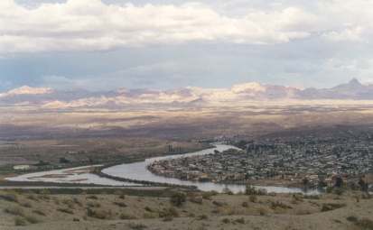
Laughlin Stretch:
Laughlin is located below Davis Dam along the Colorado River. The river in this area is used mostly as a personal watercraft, speed and pleasure boat recreation area. As the river flows by the Laughlin casinos, the traffic can get pretty crowded. Going down river, past Harrah's Del Rio Resort, the water of the Colorado smoothes out and traffic becomes much lighter. If you want to do some cutting up, this is where to go.
The farther south one heads, the more peacefully and relaxing the Colorado becomes. That is where my favorite areas exist. 10 miles south you'll run into Avi Hotel and Casino Marina. This is a good place for last minute supplies, including gas. 16 miles further down river, from the Avi, the river flows through Topock,AZ. This is where the "Gorge" begins. This is a must see place for boaters and jet skiers. Gas is also available in Topock. To get there, go left (north) at the pipeline/bridge to the marina. After you enter the Gorge, about 2 miles down river from Topock, please remember to respect the no wake and no personal watercraft areas. Remember you can always swim or tube into these great marshes. This is a good fishing area also. Please... take your trash out.
Boat launching can be found at:
Davis Dam Campground on the Arizona side. ($10.00 per day)
Riverside Resort, on the strip in Laughlin. Riverside's ramp is the
only free, no cost, ramp. (very crowded)Bayshore Inn, 5 miles south on Casino Drive. Small vessels.
Big Bend State Park has a nice ramp, never crowded, except
for holidays. Cost is $8.00 car and boat. It's on the Needles Hwy,
2 miles south of the Township of Laughlin.I'd tell you my secret spot, but it wouldn't be a secret any more.
Local River Tours
The Celebration
Leaves from the Flamingo Hilton dock
Tickets $11The Del Rio
Leaves from Harrah's Laughlin dock
Tickets $12.95 adults, $7.95 children (3-12)The Edgewater Belle
Leaves from the Edgewater dock
Tickets $11The USS Riverside
Leaves from the Riverside dock
Tickets $10London Jet Boat Tours
Leaves from Pioneer
Tickets: various prices $49 adult rd trip to Lake Havasu and London BridgeWater Taxis
All major casinos
Tickets: $2 one way, $3 rd trip
More about the entire River:
The Colorado River and its tributaries flow through the Great Basin, the Sonoran Desert and the Mojave Desert, providing water and power to the arid Southwestern U.S...
These rivers are also responsible for carving some of the most spectacular natural wonders on Earth! Today the Colorado Basin offers awesome outdoor adventure and recreation opportunities in the U.S.
Physical Phenomenon
The Colorado River is born about 10,000 feet in the Rocky Mountains of Colorado and flows southwest for 1,470 miles to the Gulf of California (Sea of Cortez) in Mexico. It is the international boundary for 17 miles between Arizona and Mexico. Before the construction of a number of dams along its route, it flowed 80 miles through Mexico to the Gulf of California.
The 1,360 miles of its route in the United States makes it the nation's fifth longest river. It drains a large portion of the North American continent covering 242,000 square miles in the United States and 3,000 square miles in Mexico. The Colorado and its tributaries drain southwestern Wyoming and western Colorado, parts of Utah, Nevada, New Mexico and California, and almost all of Arizona. Three fourths of the basin is federal land devoted to national forests and parks and Indian reservations.
Geological Survey
For more than 1,000 miles, the upper and middle portions of the Colorado River and its tributaries -- the Virgin, Kanab, Paria, Escalante, Dirty Devil and Green rivers from the west; the Little Colorado, San Juan, Dolores and Gunnison from the east -- cut a spectacular labyrinth of deep gorges. The longest and most spectacular of these canyons is the magnificent Grand Canyon, extending from the mouth of the Paria to Grand Wash Stream. Canyonlands National Park encompasses another of these regions at the juncture of the Green and Colorado rivers in southeastern Utah.
The lower Colorado River separates two great deserts, the Mojave on the western side and the Sonoran on the eastern side. The Gila River drains the Sonoran. South of the Mojave Desert lies the Salton Basin, a large depression 230 feet below sea level, extending 150 miles northwest from the head of the Gulf of California.
In 1905, floodwaters caused a levee to break on the Colorado River near Yuma; water rushed into the Salton Basin. This created the Salton Sea, about 68 feet deep, 55 miles long, and 16 miles wide, with a total water area of some 300 sq. miles. Since the break threatened the agriculturally rich Imperial Valley and a major railroad route, the levee was finally repaired in 1907, but the Salton Sea remains.
Commerce & Politics
The Colorado is a remarkable source for hydroelectric power and irrigation. Of its 10 million potential horsepower, one-fifth has been developed . 21 dams have been built on the Colorado and its tributaries. The river rarely reaches the Gulf of California because of these dams. The Morelos Diversion Dam, located on the Mexico-Arizona border is the southernmost dam on the Colorado. It sends virtually all of the remaining water to irrigation canals in the Mexicali Valley and to the towns of Mexicali and Tijuana.
The Colorado System was the first drainage basin in which the concept of the multipurpose dam was employed. In 1922 the Colorado River Compact was concluded by the seven states that constitute its drainage area. The first major development began in 1928 when Congress passed the Boulder Canyon Project Act authorizing construction of Boulder (now Hoover) Dam. Construction of this dam was considered a major engineering accomplishment of its time. Since its completion in 1936, the Hoover Dam and Lake Mead, which it created with its impounded waters, have become major tourist attractions.
Many additional projects have been completed since then. In the mid-1960s, Glen Canyon Dam was completed, impounding Lake Powell. This dam was controversial, and opposition to its construction helped shaped policy toward concepts of water management and environmental protection.
Shortly after the completion of Hoover Dam, planning and construction began downstream on the Parker Dam. From Havasu Lake, the reservoir impounded by the dam, water is transported some 250 miles across California to supply a portion of the water needs for Los Angeles and most of the water supply for San Diego. Davis, Imperial, Laguna, and Morelos dams further regulate flow and diversion in the lower basin.
In 1963 a decision of the U.S. Supreme Court made explicit the amount of water apportioned among the lower-basin states, as well as the amounts that had been implicitly "reserved" for Indian tribes and federal public lands.
This decision prompted funding of the Central Arizona Project, completed in the 1980s. The project comprises a mountain tunnel through which water from the southern end of Lake Havasu is pumped up and into an aqueduct that flows southward to the two cities of Phoenix and Tucson.
The increasingly severe competition for whatever small quantities of water remain in the Colorado River keeps the basin tied up in litigation and controversy. Water projects must now undergo thorough environmental-impact studies in accordance with federal environmental protection legislation.
History
Ute and Southern Paiute Indian tribes hunted and gathered on the plateaus and in the canyon lands of the upper Colorado basin for centuries. In the lower basin, Hohokam Indians constructed the largest prehistoric canal irrigation system in the American West on the Gila and Salt rivers. Yuman tribes practiced complicated patterns of floodplain farming and hunting on the Colorado. In the face of economic exploitation of the region by whites, and the resulting ecological changes, Indian groups have struggled to maintain vestiges of traditional lifeways with respect to the river.
Several Europeans explored the Colorado River early on, but upon discovering that it was practically useless for navigation later ignored further exploration. In 1538, Francisco de Ulloa traveled to the Colorado from the Gulf of California; in 1540, Hernando de Alarcon became the first European to sail up the river, while Garcia Lopez de Cardenas of discovered the Grand Canyon.
In 1776, Fathers Velez de Escalante and Dominguez crossed the Colorado in Glen Canyon. That same year Father Francisco Garces named the river "Colorado" because of its red mud.
Lieutenant Joseph C. Ives in 1857, maneuvered the Colorado from Black Canyon. But it wasn't until 1869 that Major John Wesley Powell made the first trip through the Grand Canyon. He led an expedition by boat, recording and mapping his journey. His journals are still in print and provide exciting reading for modern adventurers ready to discover the greatness of the Desert Southwest.
Live in Laughlin?
Visiting Laughlin?
Need Internet?
Click
Here